![]()
Continued from Grand County High Point
The rain and wind continued all night. The air in the tent was saturated with humidity and it dripped down on my bedding where it had condensed on the tent ceiling. We climbed out of the tent expecting to see a red muddy mess but amazingly, it wasn’t too bad. The storms were still everywhere so we had no regrets for skipping Mt. Peale.
The sun wasn’t even up yet but loading the truck full of gear made us poor sweat, adding more moisture to the air around us. We took our time though, cooked up some makings for breakfast burritos. I had spent some time experimenting before this trip trying to find an easy way to package food and cook it quickly and without a lot of gear. I had settled on precooking all the food, vaccuum sealing it in food-saver bags and freezing it. This helped keep the ice chests cold and eliminated the need for several pots and pans to mix and mash in. However, there are some things that just don’t taste the same after this process. One is Mac & Cheese as we found out the night before. However, a precooked mix of tator tots, sausage and eggs heats up nicely and is very tasty wrapped in warm flour tortillas.
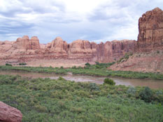
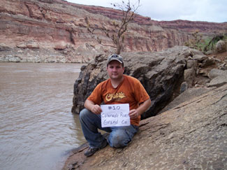
We loaded up and drove a short distance to an area just south of the Potash Boat ramp which was flooded a few weeks ago when we had initially set aside time to go. We broke out the GPS and walked toward the Grand County Low Point hoping we’d be able to get close enough to mark it off. There has been incredible flooding this year and we had no idea if we’d be able to get down to the water level with it still being high and the shoreline littered with debris. We walked right up to the lowpoint according to the gps coords...but we were still 100 feet above the river. We were tempted to count it and continue on but deep down we knew we needed to actually touch the low point or we’d be cheating ourselves. So we got down on our hands and knees, creeped to the edge of the cliff, studied the layout and decided to take a chance and see how far we could get.
We also took a moment to enjoy the most incredible echos I’ve ever experienced. The flat canyon walls were perfectly situated so that we could say several words at a time, pause for a second and hear every single one of those words repeated perfectly, almost without distortion back at us. It was as clear as if someone was 20 feet from you talking. We were even able to hear a whisper echo clearly. Amazing!
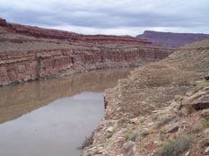
We headed back up to the truck and changed into our pants and long sleeves in preparation to yards and yards of bushwacking. We dropped down a small chute and headed a hundred yards or so along the lower cliff where we came to a narrow shelf where we had to hug the wall, making our way down to the river level. GPS still showed we were ⅕ of a mile away and looking upriver, we had no idea if that was even possible. The brush and flood debris was so thick, it was slow going. We could only imagine what the passing river rafting groups were thinking when they saw us. Maybe they didn’t even notice since they were so busy dousing themselves with sunscreen, rearrainging their beer coolers and ultimately missing the beauty around them as they floated away with their $100 sunglasses and thousand dollar cameras. Their trip was sure to be boring compared to this. They were simply going where they were taken, unable to slow down and enjoy the plants or the vistas or even take a different route. They were slaves of their rafts and were unable to truly live an adventure. Us on the other hand could pause and enjoy the world around us. Be where we wanted to be, see what we wanted to for as long as we wanted to. Nothing was pushing us downstream. We were living the moment where nothing else mattered. It wasn’t even possible for us to lose $100 sunglasses we didn’t have.
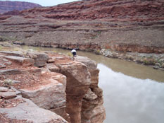
After much crashing through tangled sticks and thorny, bug infested brush, we made it to the spot, took some photos and headed back upstream - which was much easier now there was a trail......of sorts.
Back at the truck we switched back to shorts and sat with the A/C turned up full blast hoping to cool off a little as it dried our soaking wet clothes and the wet dust formed a crust on our skin.
The next spot would be the 2nd Low point in Grand County at Saddle Horse Bottom. Interesting enough, there are 2 locations for the lowest point in Grand County. Both are at the county line. Both are in different canyons nearly 20 miles apart. And Both are exactly the same height. So to truly touch the lowest point in each county......we'll have to touch both of these.