![]()
HOME
Article
GPS Track & Elevation Profile
Google Earth file (kmz)
Photo Gallery
Video
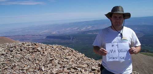
Mt. Waas - Grand County- 12,331 ft. - High-Point Rank: 4th
We left home about 2:30 in the afternoon. Headed out on a 7 + day adventure to southeast Utah. None of us had ever been to that part of the state and were excited for whatever adventure lay in wait.
With 7 days worth of water, food, clothing, some gas and bedding packed into the back of a small Tacoma, we headed up I-15 feeling every bump in the road as the weight had taken all of the “bounce” out of the truck and felt like we were riding in a vehicle without shocks.
Many hours later, we reached Green River Utah and fueled up. We then drove a little way to Moab where we filled the tank again and continued around the La Sal Mountains. We made it to Don’s Lake about ½ hour before sunset and were in awe at the beauty of this forest. It was incredibly green, lush and healthy. Very different from the beatle infested, dry forests near our home. The bald peaks towered above us as the sun splashed them with it’s last rays. There was not a soul anywhere around which seemed odd for a holiday weekend in Utah... but we weren’t complaining.
After cooking up some potatoes with vegetables and sausage; washing up in the creek, we bear proofed all we could and parked our truck a short way from the tent. We headed to bed, ready to conquer 12,331 foot Mt. Waas in the morning.
Next morning just as it was getting light, we crawled out of bed, ate some cold cereal, packed up and at about 7:15 am, we drove the rest of the way up to Beaver Basin near the base of Mt. Waas. It was a 45 minute slow, rocky drive up a narrow road, made even more uncomfortable by our tremendously heavy gear. We had decided not to spend the night at Beaver Basin since it was getting dark and we had heard there was a bear trap up there. We figured we didn’t need any more excuses to see a bear on the very first night.
When we reached Beaver Basin, there was another group that had camped there and if there was a bear bait station... we never saw it. 8 am we started our hike up the mountain. 50 feet from the truck, I was sweating from the humidity of the rising dew drops under the bright sun. I knew it was going to be a long day. I had told myself for months before that I was going to be in great physical shape before I even started this trip. In fact, I had even tried running a few miles a day about a month ago but was shut down with shin splints that have plagued me since running in High School. So here I was, puffing away and thinking of climbing straight up a mountain.
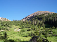
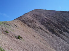
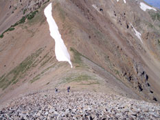
I set my sights on a saddle we decided to reach before turning and following the ridge up to the top. The crisp, clean air made it appear not too distant. We started out walking in taller grasses which flowed under a heavy pine canopy littered with fallen, rotting giants of trees. It was a beautiful morning and my eyes enjoyed every step while my body begged to rest every few feet. After weaving through this dense forrest, the vegetation suddenly ceased and what lay ahead was a barren landscape of sharp talus. Here and there appeared small patches of low grass which we decided to use as much as we could to help with our footing. We side-hilled around to the saddle and got our first real look of what Mt. Waas really was. It appeared straight up.
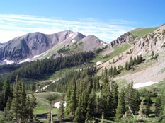
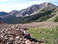
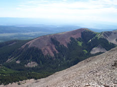
After admiring the view of Colorado to the East and Canyonlands to the West, we pushed on. After a total of 2 ½ hours of climbing, we summitted. We spent about 1 hour at the top admiring the views and enjoying the sun. Even at the top of this peak, above 12,000 feet, there wasn’t even a breeze and we soaked in every bit of sun we could. After debating whether we should return the way we came or pick a different route, we decided to stick with the sure and proven way back down.
Suddenly, the clouds began to build and darken so we hurried back down to the bottom, covering quite some distance in a fraction of the time it had taken to come up. After reaching the truck, we hung out in the pines near a running creek and ate some sandwiches and bags of smashed chips.
A few weeks before this trip, I had tracked down a camper shell to fit my truck. I remembered the previous trip to some low points in the West Desert and how tired and annoyed I had gotten at having to untie a dusty tarp everytime I needed anything from the back. I had tirelessly searched for one so I would have something to keep the rain and the dust off. However, I quickly came to the conclusion that it had it’s drawbacks as well. It was nice to just throw everything in and go. Most everything was in totes so they stacked well. However, if we needed anything from the back of the truck. We had to unload everything and then repack it. Supplies for 3 people and 7 days adds up to a lot of stuff.
After getting everything situated, we started heading down the road from Beaver Basin. All of a sudden, the storm rolled in and the lightning got close. It rained hard and even had a moment of hail. One of the best things about the mountains is being in the mountains during a lightning storm... if you’re not on the peak and you're in something that will keep you safe and dry... which we were. Now we were grateful for the rocky road because the water had no affect on the soil and slippery mud was not an issue.
After passing back by Don’s Lake where we had camped the night before, we turned South and headed around the back side of the La Sals toward Mt. Peale which we hoped to conquer the next day. The drive was beautiful and very enjoyable in the freshly washed air. We came around the corner and got our first good look at Mt. Peale and had to stop and catch our breath. It looked daunting. It appeared twice as big and twice as difficult as Mt. Waas. I was not looking forward to this climb as my sore body reminded me every time I moved of the abuse I had given it on Mt. Waas.
The dark clouds loomed all around and we debated whether to set up camp and prepare to hike Peale the next day or go hit the two nearest low points and let the storms blow over, returning on Wednesday to attempt Massive Peale. We decided to drive down to the small town of La Sal where we could just barely get cell service and check out the forecast for the area. The weather guessers were thinking Tuesday would be stormy and Wednesday wouldn’t be much better so we headed to Moab for gas and ice then on down to the Grand County low point near Potash. It was getting dark and the storms still swirled menacing around us. So we decided to delay our attempt there until tomorrow and just try and find a place to camp. We finally decided on a little turnoff where we set up camp in the wind and dust, ate burnt Mac & Cheese - which is only possible to burn while camping in the wind and dust. We rested outside in the wind and dust and watched the lightning show, basking in the pelting raindrops. The tent was steamy hot and stinky since we were unable to open the windows because of the driving rain being blown horizontally. I laid there for a while trying not to move, just feeling the heat rising from the red sandstone, through the tent floor, adding to the misery.
With 7 days worth of water, food, clothing, some gas and bedding packed into the back of a small Tacoma, we headed up I-15 feeling every bump in the road as the weight had taken all of the “bounce” out of the truck and felt like we were riding in a vehicle without shocks.
Many hours later, we reached Green River Utah and fueled up. We then drove a little way to Moab where we filled the tank again and continued around the La Sal Mountains. We made it to Don’s Lake about ½ hour before sunset and were in awe at the beauty of this forest. It was incredibly green, lush and healthy. Very different from the beatle infested, dry forests near our home. The bald peaks towered above us as the sun splashed them with it’s last rays. There was not a soul anywhere around which seemed odd for a holiday weekend in Utah... but we weren’t complaining.
After cooking up some potatoes with vegetables and sausage; washing up in the creek, we bear proofed all we could and parked our truck a short way from the tent. We headed to bed, ready to conquer 12,331 foot Mt. Waas in the morning.
Next morning just as it was getting light, we crawled out of bed, ate some cold cereal, packed up and at about 7:15 am, we drove the rest of the way up to Beaver Basin near the base of Mt. Waas. It was a 45 minute slow, rocky drive up a narrow road, made even more uncomfortable by our tremendously heavy gear. We had decided not to spend the night at Beaver Basin since it was getting dark and we had heard there was a bear trap up there. We figured we didn’t need any more excuses to see a bear on the very first night.
When we reached Beaver Basin, there was another group that had camped there and if there was a bear bait station... we never saw it. 8 am we started our hike up the mountain. 50 feet from the truck, I was sweating from the humidity of the rising dew drops under the bright sun. I knew it was going to be a long day. I had told myself for months before that I was going to be in great physical shape before I even started this trip. In fact, I had even tried running a few miles a day about a month ago but was shut down with shin splints that have plagued me since running in High School. So here I was, puffing away and thinking of climbing straight up a mountain.
I set my sights on a saddle we decided to reach before turning and following the ridge up to the top. The crisp, clean air made it appear not too distant. We started out walking in taller grasses which flowed under a heavy pine canopy littered with fallen, rotting giants of trees. It was a beautiful morning and my eyes enjoyed every step while my body begged to rest every few feet. After weaving through this dense forrest, the vegetation suddenly ceased and what lay ahead was a barren landscape of sharp talus. Here and there appeared small patches of low grass which we decided to use as much as we could to help with our footing. We side-hilled around to the saddle and got our first real look of what Mt. Waas really was. It appeared straight up.
After admiring the view of Colorado to the East and Canyonlands to the West, we pushed on. After a total of 2 ½ hours of climbing, we summitted. We spent about 1 hour at the top admiring the views and enjoying the sun. Even at the top of this peak, above 12,000 feet, there wasn’t even a breeze and we soaked in every bit of sun we could. After debating whether we should return the way we came or pick a different route, we decided to stick with the sure and proven way back down.
Suddenly, the clouds began to build and darken so we hurried back down to the bottom, covering quite some distance in a fraction of the time it had taken to come up. After reaching the truck, we hung out in the pines near a running creek and ate some sandwiches and bags of smashed chips.
A few weeks before this trip, I had tracked down a camper shell to fit my truck. I remembered the previous trip to some low points in the West Desert and how tired and annoyed I had gotten at having to untie a dusty tarp everytime I needed anything from the back. I had tirelessly searched for one so I would have something to keep the rain and the dust off. However, I quickly came to the conclusion that it had it’s drawbacks as well. It was nice to just throw everything in and go. Most everything was in totes so they stacked well. However, if we needed anything from the back of the truck. We had to unload everything and then repack it. Supplies for 3 people and 7 days adds up to a lot of stuff.
After getting everything situated, we started heading down the road from Beaver Basin. All of a sudden, the storm rolled in and the lightning got close. It rained hard and even had a moment of hail. One of the best things about the mountains is being in the mountains during a lightning storm... if you’re not on the peak and you're in something that will keep you safe and dry... which we were. Now we were grateful for the rocky road because the water had no affect on the soil and slippery mud was not an issue.
After passing back by Don’s Lake where we had camped the night before, we turned South and headed around the back side of the La Sals toward Mt. Peale which we hoped to conquer the next day. The drive was beautiful and very enjoyable in the freshly washed air. We came around the corner and got our first good look at Mt. Peale and had to stop and catch our breath. It looked daunting. It appeared twice as big and twice as difficult as Mt. Waas. I was not looking forward to this climb as my sore body reminded me every time I moved of the abuse I had given it on Mt. Waas.
The dark clouds loomed all around and we debated whether to set up camp and prepare to hike Peale the next day or go hit the two nearest low points and let the storms blow over, returning on Wednesday to attempt Massive Peale. We decided to drive down to the small town of La Sal where we could just barely get cell service and check out the forecast for the area. The weather guessers were thinking Tuesday would be stormy and Wednesday wouldn’t be much better so we headed to Moab for gas and ice then on down to the Grand County low point near Potash. It was getting dark and the storms still swirled menacing around us. So we decided to delay our attempt there until tomorrow and just try and find a place to camp. We finally decided on a little turnoff where we set up camp in the wind and dust, ate burnt Mac & Cheese - which is only possible to burn while camping in the wind and dust. We rested outside in the wind and dust and watched the lightning show, basking in the pelting raindrops. The tent was steamy hot and stinky since we were unable to open the windows because of the driving rain being blown horizontally. I laid there for a while trying not to move, just feeling the heat rising from the red sandstone, through the tent floor, adding to the misery.