View This Map full screen
![]() low point
low point ![]() high point
high point ![]()
![]() completed
completed
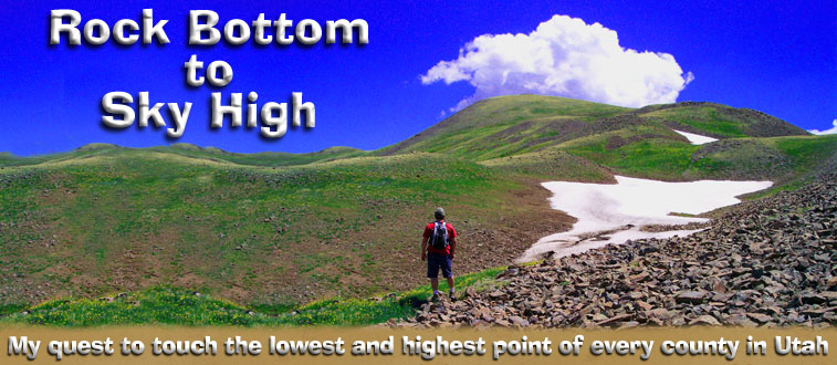
I have never really been into hiking much. I'm not a fan of blisters, sweat, bugs, and pain. It has been a long time since I've been in good enough physical shape to go very far without huffing and puffing.
However, in June 2010 after reading several blogs and online journals of long distance hikers, I became intrigued with accomplishing something that not too many have. I know I won't be able to do a long-distance hike such as the Appalachian or the Pacific Crest trails but I want to experience similar challenges. I want to enjoy the rock in my path, the pelting rain in my face, the sun burning my neck. I want to see the lightning in the forest, the flowers in the fields, the eagle on the cliff. I need a new hobby and a goal that will take several years. I want to have a story to tell.
These are my adventures: from the best to the worst, the huffing to the puffing, the lowest to the highest.
This is my story from Rock Bottom to Sky High.
 |
|
| COUNTY | LOCATION | ELEV |
COMPLETED |
|||||
| Duchesne | Kings Peak | 13,528 |
||||||
Summit |
13,442 |
|||||||
San Juan |
12,721 |
07/27/2011 |
||||||
| Grand | Mount Waas | 12,331 |
07/25/2011 |
|||||
Daggett |
12,276 |
|||||||
Uintah |
12,276 |
|||||||
Beaver |
12,169 |
07/14/2010 |
||||||
Piute |
12,169 |
07/14/2010 |
||||||
Juab |
12,087 |
|||||||
Utah |
11,928 |
|||||||
Sevier |
11,633 |
10/02/2014 |
||||||
Garfield |
11,522 |
07/30/2011 |
||||||
Salt Lake |
11,489 |
|||||||
Wayne |
11,320 |
07/30/2011 |
||||||
Iron |
11,307 |
10/02/2014 |
||||||
Sanpete |
11,285 |
08/01/2013 |
||||||
Tooele |
11,031 |
|||||||
Wasatch |
Murdock Mountain - West Slope |
10,840 |
||||||
Emery |
10,743 |
07/31/2013 |
||||||
Carbon |
10,452 |
07/31/2013 |
||||||
Washington |
10,365 |
07/10/2010 |
||||||
Millard |
10,222 |
|||||||
Kane |
10,080 |
10/02/2014 |
||||||
Cache |
9,979 |
|||||||
Box Elder |
9,925 |
|||||||
Weber |
9,763 |
|||||||
Davis |
9,706 |
|||||||
Morgan |
9,706 |
|||||||
Rich |
9,255 |
COUNTY
|
LOCATION
|
ELEV |
COMPLETED |
|||||
| Washington | Beaver Dam Wash | 2,170 |
||||||
| Garfield | Bullfrog | 3,701 |
||||||
| Kane | Bullfrog Bay | 3,701 |
||||||
| San Juan | Hall's Crossing | 3,701 |
||||||
| Wayne | Colorado River | 3,865 |
07/28/2011 |
|||||
| Grand | Saddle Horse Bottom | 3,944 |
07/29/2013 |
|||||
| Grand | South of J L Eddy | 3,944 |
07/26/2011 |
|||||
| Emery | Saddle Horse Bottom | 3,944 |
07/29/2013 |
|||||
| Tooele | Black Rock | 4,203 |
10/17/2010 |
|||||
| Weber | Ogden Bay WMA | 4,203 |
||||||
| Box Elder | Bear River Bird Refuge | 4,203 |
||||||
| Davis | Great Salt Lake | 4,203 |
||||||
| Salt Lake | Great Salt Lake | 4,203 |
10/17/2010 |
|||||
| Juab | Great Salt Lake Desert | 4,273 |
||||||
| Millard | Tule Valley | 4,308 |
09/10/2010 |
|||||
| Uintah | Bluebell Island | 4,364 |
||||||
| Carbon | Chandler Falls | 4,372 |
||||||
| Uintah | Chandler Falls | 4,374 |
||||||
| Cache | Clay Slough | 4,407 |
||||||
| Cache | Benson Marina | 4,407 |
||||||
| Utah | Jordan River Parkway | 4,475 |
10/18/2010 |
|||||
| Beaver | Wah Wah Valley | 4,669 |
09/10/2010 |
|||||
| Morgan | Weber River | 4,780 |
10/17/2010 |
|||||
| Duchesne | Nine Mile Canyon | 4,843 |
07/30/2013 |
|||||
| Sanpete | Sevier Bridge Reservoir | 4,980 |
||||||
| Iron | Escalante Desert | 5,051 |
09/09/2010 |
|||||
| Sevier | Sevier River | 5,082 |
||||||
| Wasatch | Provo River | 5,235 |
10/18/2010 |
|||||
| Summit | Weber River | 5,253 |
10/17/2010 |
|||||
| Daggett | Brown's Park | 5,364 |
||||||
| Piute | Sevier River | 5,804 |
||||||
| Rich | Bear Lake | 5,923 |