![]()
HOME
Article
GPS Track & Elevation Profile
Google Earth file (kmz)
Photo Gallery
Video
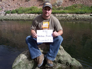
Weber River - Summit County - 4,669 ft. - Low-Point Rank: 26th
Time for another vacation! We decided to take Korbin to the Hogle Zoo and to Lagoon Theme Park over UEA weekend. And it seemed like a good excuse to hit some low points in the Salt Lake Area.
We decided to dedicate the entire third day of our trip to finding as many low points as we could. I had planned to visit 11 total but I always underestimate the time it takes to do them. They don’t look like much on Google Earth but bushwacking coupled with drive-time seems to take longer than I plan. But that’s OK; just taking my time, enjoying the views and the challenge.
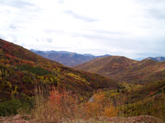
We left mid-morning and headed east on I-80 taking the East Canyon Road over to East Canyon Reservoir and joining up with I-84 on our way to the Summit County Low Point. It was overcast with a little sunlight shining through the breaks in the clouds. The orange, green, yellow, red, and purple fall colors that painted the hillsides were gorgeous. East Canyon Road had very little traffic on it and the drive was peaceful. Once a moose ran across the highway in front of us, crashing down the embankment disregarding the nearby sign that read “Don’t make new trails.”
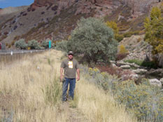
While traveling West on I-84, we actually had to take an exit in Morgan County and hike back up the Weber River to the county line. From the exit, it was about 3/4 mile one way along I-84. The traffic was annoying and I was sure someone was going to call Highway Patrol and say there was a stranded family hiking down the highway. The trail was very distinct and obviously had been used by numerous fishermen hiking up and down the river. We even walked by a fisherman standing knee deep in the water as he pulled out a small trout which he quickly released back into the river.
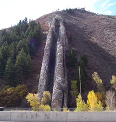
We probably could have pulled off of I-84 earlier where others had or even driven back East along the trail we walked up but it was good to exercise the legs and the weather was perfect for it. The only bad thing on this hike was walking right next to traffic and all the noise pollution but oh well. After finally making it to the lowest point along the river, we headed back to the car. We then stopped and looked at a unique rock formation just a little ways down the river called “Devil’s Slide”. This consists of two parallel limestone formations that protrude about 40 feet out of the mountainside and form a channel close to 25 feet wide, running hundreds of feet down the mountain side. After waiting for some tourists in an RV while they scrounged a rotting Elk head from the bushes to save for who knows what, we were back on our way further down the river and toward Morgan County’s low point.
We decided to dedicate the entire third day of our trip to finding as many low points as we could. I had planned to visit 11 total but I always underestimate the time it takes to do them. They don’t look like much on Google Earth but bushwacking coupled with drive-time seems to take longer than I plan. But that’s OK; just taking my time, enjoying the views and the challenge.
We left mid-morning and headed east on I-80 taking the East Canyon Road over to East Canyon Reservoir and joining up with I-84 on our way to the Summit County Low Point. It was overcast with a little sunlight shining through the breaks in the clouds. The orange, green, yellow, red, and purple fall colors that painted the hillsides were gorgeous. East Canyon Road had very little traffic on it and the drive was peaceful. Once a moose ran across the highway in front of us, crashing down the embankment disregarding the nearby sign that read “Don’t make new trails.”
While traveling West on I-84, we actually had to take an exit in Morgan County and hike back up the Weber River to the county line. From the exit, it was about 3/4 mile one way along I-84. The traffic was annoying and I was sure someone was going to call Highway Patrol and say there was a stranded family hiking down the highway. The trail was very distinct and obviously had been used by numerous fishermen hiking up and down the river. We even walked by a fisherman standing knee deep in the water as he pulled out a small trout which he quickly released back into the river.
We probably could have pulled off of I-84 earlier where others had or even driven back East along the trail we walked up but it was good to exercise the legs and the weather was perfect for it. The only bad thing on this hike was walking right next to traffic and all the noise pollution but oh well. After finally making it to the lowest point along the river, we headed back to the car. We then stopped and looked at a unique rock formation just a little ways down the river called “Devil’s Slide”. This consists of two parallel limestone formations that protrude about 40 feet out of the mountainside and form a channel close to 25 feet wide, running hundreds of feet down the mountain side. After waiting for some tourists in an RV while they scrounged a rotting Elk head from the bushes to save for who knows what, we were back on our way further down the river and toward Morgan County’s low point.