![]()
HOME
Article
GPS Track & Elevation Profile
Google Earth file (kmz)
Photo Gallery
Video
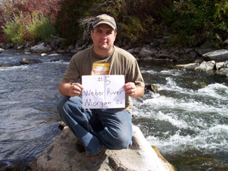
Weber River - Morgan County- 4,780 ft. - Low-Point Rank: 20th
Just a few miles down Weber Canyon from Summit County Low Point, we took a rest stop exit which had a nice park with some picnic tables. We filled up on the crackers, cheese, granola bars and bagels and took off on a short hike to Morgan County’s low point.
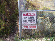
We had to skirt around a fenced area near a small dam on the river. There were signs everywhere warning fishermen and other visitors that the water levels could rise rapidly and to “listen to the horn.” While in this area there were several trains that passed by, verifying the fact that this was a major route through the mountains for them. We were even successful in getting one to pull his horn for our entertainment....hopefully not confusing others in the area that the water was going to “rapidly rise”.
After a short walk under the freeway bridges along the river, we found the low spot and noticed once again we probably could have driven a lot closer to it. But that would have been too easy.
We returned to the car and continued along I-84 back toward SLC still awed by the fall colors. We had originally planned to go up to Logan and grab Cache County’s low point but it was getting late in the day and while we could have made it there by dark, we didn’t want to drive all the way back in the dark. We chose instead to go touch the Great Salt Lake at Black Rock Point where we were able to complete two counties at once: Salt Lake and Tooele.