![]()
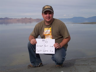
Several years ago while living in the Salt Lake area, we took a trip out to Antelope Island just to say we did. I distinctly remember driving along that long narrow road to the island and smelling the stagnant, bug-infested lake. It reaked horrible and I wasn’t too excited to visit the stench again.
We got off of I-80 at the old Saltair resort and continued West, passing the Great Salt Lake State Marina. The road was a little rough for our car but we made it to the point with not much trouble along with several other cars. There is a huge mound of rocks at this point that has been the recipient of much spray paint over the years. I would have liked to climb on top of it but not bad enough to try and find the hidden way up.
We were welcomed by that familiar stink as we stepped out of the car but it wasn’t nearly as bad as I had remembered it. As we walked, thousands of little tiny bugs would jump/fly along the ground just a step ahead of us, almost like we were hearding them around.
There was a young couple with Washington license plates who had their 1 year old daughter out there stripped naked, letting her wander around in the lake....which wasn’t all that warm.
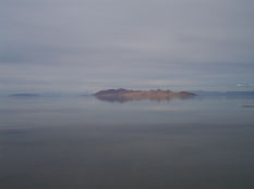
KSL recently had a news story about a week ago that said the water levels of the Great Salt Lake are hitting their lowest point since the early 1960's. They reported that many of the boats in the marinas are trapped by the low water. We did notice how far the water had receded. So I guess we actually touched a low point that possibly hadn't been seen in decades. Now off for a quick walk to Tooele County.