![]()
HOME
Article
GPS Track & Elevation Profile
Google Earth file (kmz)
Photo Gallery
Video
Colorado River - Wayne County - 3,865 ft. - Low-Point Rank: 5th
I had called the ranger station while in Moab to ask about road conditions and the ranger said they were fine in the park but the road to the Ranger Station from Highway 24 was impassable. County Roads were supposedly out there working on it but the rain had done quite a bit of damage. We decided that after our 10 mile extreme 4WD trip from Mt. Peale, we could get over or around anything so we continued undaunted.
After turning off the Highway and traveling a few miles on the dirt road, we saw many places that had washed out. Sometime during the last storm, the road had become a raging river and taken all but a couple of feet of the road with it barely allowing me to squeeze by. We came to a spot where the water had left a 2 foot deep ditch across the road that seemed impassable. It was getting dark so we quickly turned around, took a side road and located an open, quiet turnoff to pitch our tent.....among a bunch of mosquitoes that seem to have been following us for several days.
I rested extremely well that night since there were absolutely no sounds in the desert except for a few distant coyotes and a dumb bug who repeatedly bashed its head into the tent trying to get to the light inside. The temperature was great. I had no worries about bears wandering into camp and there weren’t even any crickets.....just peace and quiet.
We weren’t sure what we’d do the next day. We considered trying to find a side road around the washout or go hike Mt. Ellen in the nearby Henry Mountains and then take our route the opposite direction through Canyonlands, hoping the road would be repaired by the time we made it out..... if it ever stops raining. Or maybe we would take a shovel and go repair the road ourselves.
When we had initially planned this trip, the weather forecast showed a small shower on Tuesday but somehow, monsoon type storm developed and the entire week was filled with storms. This night we could see the Henry Mountains getting pelted by lots of rain in the distance.
We all slept in a little later than we wanted to but felt pretty rested this morning. We tried to shake as much dew off everything and attempted to listen for the sounds of a road grader in the distance in hopes of having a newly repaired road to travel on. About 9 am, it got too hot to be outside the truck so we loaded up and left toward the main road. When we got there, we could tell no one else had been on the road yet so we made our way toward an alternate route we found on the map that looked like it would take us back to Hans Flat Road after the washout. It was a long straight road that had quite a few nasty spots full of water from the rains a couple days before. Some sections I really had to get going fast and plow through hoping I wouldn’t get stuck. A couple times Dad and my brother would have to walk ahead to see how bad it really was. We came to one place that the road crossed a huge wash that had gotten a ton of water in it fromt he storms. It was a good 150 feet across. I jumped the side of the road and circumnavigated some of it but was forced through another part. I almost got stuck, bogging down about 30 feet short of firmer ground. I stepped on the gas and barely made it through. Further along, we came upon another very muddy, wet section and decided getting out of the ruts would be the best choice. I attempted to jump the edge of the road and got my front wheels over the embankment. I gunned it but my back wheels sitting under the heavy load would not go over the side. I ended up moving sideways down the road, straddling the embankment for 30 feet before finally getting out of the road. It was quite fun actually.
After more than an hour, we finally made it back to the main Han’s Flat Road and continued our way to the ranger station. The road wasn’t bad at all after that. A couple miles prior to reaching the station, we were passed by several NPS employees who must have just gotten word that the road had been reopened because they were sure in a hurry to leave the area. We made it to the ranger station, paid the $30 fee, listened to all the rules, regulations and warnings advising us that once we left the station, we were basically on our own. the ranger had no idea on the condition of the road we were taking because no one had checked it out since the last big storm. We decided to take our chances. We knocked whatever mud we could off our mudflaps so we could locate the bolts and removed them. I had learned many years earlier to remove the mudflaps in situations like this because I had ripped a few of them off by pinning them between my tire and a large rock while trying to reverse.
Finally we began to make our way down the Flint Trail which had no fresh tire tracks whatsoever. the ranger had told us that if there was a problem with the road, we could return and she’d find a campsite up top for us. This was very nice of her but was not at all helpful if we wanted to reach the lowpoint - the very reason we were out in the middle of nowhere on what was soon to become an extremely technical 4WD road in the middle of summer.
Immediately after leaving the ranger station, we could tell there had been a lot of rain and the road was in pretty bad shape. A few miles later we came to a wash were the metal culvert had been completely washed out. Large ditches on each side of the culvert. This trip was going to take a lot longer than we thought. We broke out the shovel and by filling the wash with logs, rocks and dirt, we made it barely passable and continued on our way again.
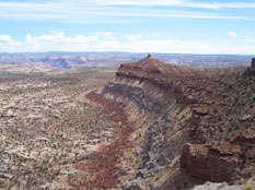
We arrived at the infamous Flint Trail switchbacks where a road heads down a very steep canyon. the ranger had said it was probably a good idea to walk the road first in case any boulders had fallen and blocked it since it would be extremely difficult to turn around and drive back up. We figured this was a good idea based on the road conditions thus far. My dad headed down the road and waved us down when everything looked clear.
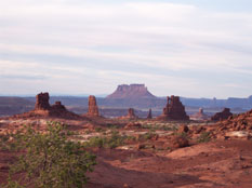
The road was steep and narrow but overall, in decent condition. The rest of the way to the dollhouse was slow going with very rough and technical 4WD spots. many times we had to stop and look at all the possible paths. My dad and brother spent a long time walking and scouting things out. They easily walked faster than I was able to drive. Part way down, we stopped and refilled the gas tank with 10 gallons we had carried in the bed since Green River. After 8 hours of driving, we got to the Dollhouse just as it was getting dark. My neck, back and legs were so stiff from being tense and gripping the stearing wheel for that long. I felt as if I had hiked up another peak.
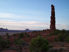
There were some sections that were very difficult but my truck handled them surprisingly well. I had researched this trip extensively before leaving and many had told of a 2-mile stretch that would take 2 hours to drive. They did not lie. We ended up traveling 43 miles in 8 hours. We knew we’d be hiking the low point and then making the drive again. We had skipped lunch that day because we didn’t want to unload the truck yet again to get to it. That has gotten to become quite monotonous. We heated up spaghetti and it tasted great. There was absolutely no wind or noise, just crickets chirping. There is not another human being within miles and miles. We camped in an area with a gorgeous view. This is the backcountry in Canyonlands and the few visitors per year that come here are required to carry out everything with them. We decided not to build a fire because we didn’t want to pack out the ashes. I had grabbed a 5 gallon bucket, some kitty litter and some waste bags so we could bear to carry out the human waste. It was a pristine area and I’m glad they are keeping it that way. We headed to bed in order to be ready for what tomorrow would bring.
Friday July 29, 2011
We slept great. Arose at 5:30 and chose to walk from our campsite at Dollhouse #3 over to the trailhead which was about ½ mile away. We then started down a steep switchback descent for about 1 mile. We made good time and reached the river excited there were no mosquitoes. We had finally managed to ditch them for the first time... or perhaps they had given up since they couldn’t find anywhere new to feast on.
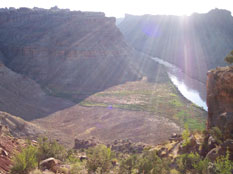
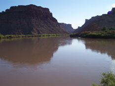
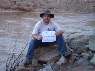
We continued downstream on a trail that ran right next to the river for another ½ mile to the low point. The Colorado river is huge and is so muddy - thus the name. After checkin in at the lowpoint we continued further downstream for ¼ mile to a neat sandy beach in perfect view of the first rapids of the famed Cataract Canyon - The Brown Betty Rapids.
After watching the raging river with awe for some time, we headed back to Spanish Bottoms and the dreaded climb back to the top. 1200 feet in 1 mile. The problem we had and knew before hand was that the slope we were climbing out on, faced East and of the course was in full attack of the sun. We paused often as we climbed, wheezing and pouring sweat, rarely being able to find any shade to rest in on the exposed rocky slope. We finally made it to the top and walked back to our campsite where we packed everything up in the full sun as well.
We then set off on our 30 mile 6 hour drive out of the park. I felt a lot more confident on the rocky road, better knowing what my truck would handle. I made it out of there 2 hours faster than we did coming in. My dad and brother didn’t have to get out of the truck and check the road nearly as much that day. I was able to handle many sections on my own that would have made me hesitate just the day before.
We drove up to Hanksville for gas and ice before heading off to Mt. Ellen. We found a good camping spot about 2 ½ miles from the pass where we’d start hiking the next day. For only the 2nd time this entire trip, we built a fire. It was good feeling its warmth and mezmerizing look and the hotdogs tasted delicious.
We also took showers in our tarp enclosure and felt relaxed and clean. It had been a long day in the sun. 1 more low point completed. Tomorrow we’d hit 2 more highpoints, then off to home after 7 days of adventure.
After turning off the Highway and traveling a few miles on the dirt road, we saw many places that had washed out. Sometime during the last storm, the road had become a raging river and taken all but a couple of feet of the road with it barely allowing me to squeeze by. We came to a spot where the water had left a 2 foot deep ditch across the road that seemed impassable. It was getting dark so we quickly turned around, took a side road and located an open, quiet turnoff to pitch our tent.....among a bunch of mosquitoes that seem to have been following us for several days.
I rested extremely well that night since there were absolutely no sounds in the desert except for a few distant coyotes and a dumb bug who repeatedly bashed its head into the tent trying to get to the light inside. The temperature was great. I had no worries about bears wandering into camp and there weren’t even any crickets.....just peace and quiet.
We weren’t sure what we’d do the next day. We considered trying to find a side road around the washout or go hike Mt. Ellen in the nearby Henry Mountains and then take our route the opposite direction through Canyonlands, hoping the road would be repaired by the time we made it out..... if it ever stops raining. Or maybe we would take a shovel and go repair the road ourselves.
When we had initially planned this trip, the weather forecast showed a small shower on Tuesday but somehow, monsoon type storm developed and the entire week was filled with storms. This night we could see the Henry Mountains getting pelted by lots of rain in the distance.
We all slept in a little later than we wanted to but felt pretty rested this morning. We tried to shake as much dew off everything and attempted to listen for the sounds of a road grader in the distance in hopes of having a newly repaired road to travel on. About 9 am, it got too hot to be outside the truck so we loaded up and left toward the main road. When we got there, we could tell no one else had been on the road yet so we made our way toward an alternate route we found on the map that looked like it would take us back to Hans Flat Road after the washout. It was a long straight road that had quite a few nasty spots full of water from the rains a couple days before. Some sections I really had to get going fast and plow through hoping I wouldn’t get stuck. A couple times Dad and my brother would have to walk ahead to see how bad it really was. We came to one place that the road crossed a huge wash that had gotten a ton of water in it fromt he storms. It was a good 150 feet across. I jumped the side of the road and circumnavigated some of it but was forced through another part. I almost got stuck, bogging down about 30 feet short of firmer ground. I stepped on the gas and barely made it through. Further along, we came upon another very muddy, wet section and decided getting out of the ruts would be the best choice. I attempted to jump the edge of the road and got my front wheels over the embankment. I gunned it but my back wheels sitting under the heavy load would not go over the side. I ended up moving sideways down the road, straddling the embankment for 30 feet before finally getting out of the road. It was quite fun actually.
After more than an hour, we finally made it back to the main Han’s Flat Road and continued our way to the ranger station. The road wasn’t bad at all after that. A couple miles prior to reaching the station, we were passed by several NPS employees who must have just gotten word that the road had been reopened because they were sure in a hurry to leave the area. We made it to the ranger station, paid the $30 fee, listened to all the rules, regulations and warnings advising us that once we left the station, we were basically on our own. the ranger had no idea on the condition of the road we were taking because no one had checked it out since the last big storm. We decided to take our chances. We knocked whatever mud we could off our mudflaps so we could locate the bolts and removed them. I had learned many years earlier to remove the mudflaps in situations like this because I had ripped a few of them off by pinning them between my tire and a large rock while trying to reverse.
Finally we began to make our way down the Flint Trail which had no fresh tire tracks whatsoever. the ranger had told us that if there was a problem with the road, we could return and she’d find a campsite up top for us. This was very nice of her but was not at all helpful if we wanted to reach the lowpoint - the very reason we were out in the middle of nowhere on what was soon to become an extremely technical 4WD road in the middle of summer.
Immediately after leaving the ranger station, we could tell there had been a lot of rain and the road was in pretty bad shape. A few miles later we came to a wash were the metal culvert had been completely washed out. Large ditches on each side of the culvert. This trip was going to take a lot longer than we thought. We broke out the shovel and by filling the wash with logs, rocks and dirt, we made it barely passable and continued on our way again.
We arrived at the infamous Flint Trail switchbacks where a road heads down a very steep canyon. the ranger had said it was probably a good idea to walk the road first in case any boulders had fallen and blocked it since it would be extremely difficult to turn around and drive back up. We figured this was a good idea based on the road conditions thus far. My dad headed down the road and waved us down when everything looked clear.
The road was steep and narrow but overall, in decent condition. The rest of the way to the dollhouse was slow going with very rough and technical 4WD spots. many times we had to stop and look at all the possible paths. My dad and brother spent a long time walking and scouting things out. They easily walked faster than I was able to drive. Part way down, we stopped and refilled the gas tank with 10 gallons we had carried in the bed since Green River. After 8 hours of driving, we got to the Dollhouse just as it was getting dark. My neck, back and legs were so stiff from being tense and gripping the stearing wheel for that long. I felt as if I had hiked up another peak.
There were some sections that were very difficult but my truck handled them surprisingly well. I had researched this trip extensively before leaving and many had told of a 2-mile stretch that would take 2 hours to drive. They did not lie. We ended up traveling 43 miles in 8 hours. We knew we’d be hiking the low point and then making the drive again. We had skipped lunch that day because we didn’t want to unload the truck yet again to get to it. That has gotten to become quite monotonous. We heated up spaghetti and it tasted great. There was absolutely no wind or noise, just crickets chirping. There is not another human being within miles and miles. We camped in an area with a gorgeous view. This is the backcountry in Canyonlands and the few visitors per year that come here are required to carry out everything with them. We decided not to build a fire because we didn’t want to pack out the ashes. I had grabbed a 5 gallon bucket, some kitty litter and some waste bags so we could bear to carry out the human waste. It was a pristine area and I’m glad they are keeping it that way. We headed to bed in order to be ready for what tomorrow would bring.
Friday July 29, 2011
We slept great. Arose at 5:30 and chose to walk from our campsite at Dollhouse #3 over to the trailhead which was about ½ mile away. We then started down a steep switchback descent for about 1 mile. We made good time and reached the river excited there were no mosquitoes. We had finally managed to ditch them for the first time... or perhaps they had given up since they couldn’t find anywhere new to feast on.
We continued downstream on a trail that ran right next to the river for another ½ mile to the low point. The Colorado river is huge and is so muddy - thus the name. After checkin in at the lowpoint we continued further downstream for ¼ mile to a neat sandy beach in perfect view of the first rapids of the famed Cataract Canyon - The Brown Betty Rapids.
After watching the raging river with awe for some time, we headed back to Spanish Bottoms and the dreaded climb back to the top. 1200 feet in 1 mile. The problem we had and knew before hand was that the slope we were climbing out on, faced East and of the course was in full attack of the sun. We paused often as we climbed, wheezing and pouring sweat, rarely being able to find any shade to rest in on the exposed rocky slope. We finally made it to the top and walked back to our campsite where we packed everything up in the full sun as well.
We then set off on our 30 mile 6 hour drive out of the park. I felt a lot more confident on the rocky road, better knowing what my truck would handle. I made it out of there 2 hours faster than we did coming in. My dad and brother didn’t have to get out of the truck and check the road nearly as much that day. I was able to handle many sections on my own that would have made me hesitate just the day before.
We drove up to Hanksville for gas and ice before heading off to Mt. Ellen. We found a good camping spot about 2 ½ miles from the pass where we’d start hiking the next day. For only the 2nd time this entire trip, we built a fire. It was good feeling its warmth and mezmerizing look and the hotdogs tasted delicious.
We also took showers in our tarp enclosure and felt relaxed and clean. It had been a long day in the sun. 1 more low point completed. Tomorrow we’d hit 2 more highpoints, then off to home after 7 days of adventure.