![]()
Continued from Grand County Low Point #1
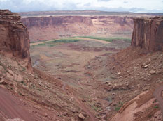
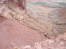
We headed along Mineral Bottom Road and came to the place where w start dropping down the canyon to the river. Last year, a mudslide had completely destroyed the winding road down. They had recently repaired it and it was in great condition. The view was grand and the drive down was satisfying.
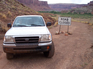
After reaching the bottom, we came to a road that forked off to the left. This road would take us the last 4 miles to the lowpoint in Labryinth Canyon at the border of Canyonlands National Park. As soon as we started down that road, we ran into a big “Road Closed” sign that stopped us short. We sat there deflated because we were so close...yet so far. We turned around and drove to a nearby boat ramp to take a closer look at the river we would be swimming across further downstream. It was wide and flowing fast, creating many eddies and undertows, bubbling and swirling. The water wasn’t warm, yet not too chilly.
We had to make a decision. We could hike the remaining 4 miles along the flat road to get to our destination. We would have to carry our life vests, blow-up water mattress’s and a dry change of clothes... or we could circumvent the “Road Closed” sign and see how far we could get. We noticed a smaller sign saying that the road was closed from the Canyonlands boundary to Potato bottom which we discovered was even further south than where we were going. We now interpreted the “road closed” sign blocking our path as a warning that the road was closed further on down than where we were going. I turned the wheel ever so slightly and the large sign was in my rear view mirror. However, it didn’t take long for the road to get softer and muddier. I was in 4WD and was fishtailing and spinning all over the place, afraid to stop for fear of never being able to get going again. This was much more fun than driving the miles and miles of pavement that most people only get to see during their lifetime.
We drove up to a spot where we could tell someone had gotten stuck and had really turned the road into a mess trying to free themselves. We decided to scout ahead by foot to see if it was worth the chance of pushing forward. Rather, I sent my dad ahead to scout around the bend. He took off from the truck, running and swatting at mosquitoes that were trying to carry him away. He jumped ditches and puddles, disappearing around a bend as we sat in the truck and watched the swarm of mosquitoes attack the outside of the windows like woodpeckers trying to penetrate the glass. A few seconds later, he came running back around the bend, coughing and spitting, He was tired and each time he inhaled, he sucked in mosquitoes by the mouthful. His white, pale legs were now red and covered with bites. My dad had done this before with my brother a few miles back......but this time, my brother was smart enough to stay inside to help slaughter the army of mosquitoes that managed to sneak in everytime the door was opened for a split second.
We concluded that we couldn’t drive any further and the “road closed” sign was actually correct. There was no way we were going to hike the 3 miles that were left through the fog of mosquitoes. These 2 county low points would have to wait until another year to be reached.....and we’d have to bring a flamethrower with us.
We headed back past the road closed sign with our tails between our legs and back up out of the canyon. After restocking ice in Moab and making some phone calls, we decided our best bet at hiking Mt. Peale would be the next mroning even though showers were predicted through the night and throughout tomorrow. We decided to camp at the base of Giant Mt. Peale and see what tomorrow would bring. We drove back up to La Sal Pass and took a side road I had read about that would move our starting point about a mile closer and 1000 feet higher. We set up camp, ate rice with stir-fried vegetables, took a cold shower behind a tarp rigged up in the trees and watched the fog roll in and out of the valley a couple of times. We left our truck with all of our stuff packed in it down where we had cooked dinner, about 200 yards from the tent and being freshly clean, we crawled into our dirty beds.
Our plans were to wake at 5:00 and see what the weather was doing and decide to make the agonizing climb or not. The wind started to howl and the rain picked up in the night. I tried to get a little sleep in the 4 ½ hours that remained.
Continued at Mt. Peale