![]()
So, there is a disorder in my family that my father got from somewhere and which has been passed down to my brother and I. It is an ailment that we’ve had for as long as I can remember but only surfaces every once in a while. It’s called: “We are in bad shape, we haven’t done anything active for a very long time…..let’s go hike 15 miles in rough terrain.” There are no “5 mile preparation hikes” or “let’s take it easy and see how it goes”.
It usually happens in October when we tear our houses apart looking for hiking gear we haven’t seen since the previous year's deer hunt. Then we set out before daylight, hiking everywhere we can while glassing any slope we find. One of us usually ends up shooting a deer as soon as everyone is utterly exhausted from the hike. And of course, we are in an area that no ATV or horse could possibly go. So we end up dragging the deer for miles. Up and down, through thick brush and over logs, abusing our bodies and tenderizing the deer meat….and then we go home and say it was the funnest day ever……..?
However, this year it came a few months earlier. It's not deer hunting season and without any short preparation hikes or bike rides or anything, we decide to dig out our hiking gear and daypacks (which to my surprise…and delight, still had food in it from the deer hunt 9 months earlier) and hike the highest point in Washington County.
We decided to go up the Forsyth Trail since I have never hiked it and it seemed more pleasant than the sun- baked and steep Oak Grove Trail which we have been up several times before. We also planned on coming down the Browns Point Trail – since we always try to return a different way than we left. Hopefully we could find someone to give us a ride the several miles back to our vehicle.
We Started hiking about 6:40 am. The temperature was perfect and the trail was great. I took full advantage of wearing shorts for the first time while hiking, knowing there would be no deer to drag and that the trails were “well defined and maintained”. Immediately though, I noticed how black my socks were getting with each puff of fine silt created by every footstep. Nevertheless, I didn’t regret wearing them once.
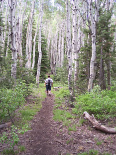
The Forsyth Trail follows Forsyth Creek up a canyon for most of the way and it was great to see all the snowmelt. We seemed to be making good time, even though I slowed us down by having to repeatedly track down pieces of my backpack that would fall off. The canyons were beautiful. Tall pines growing next to the river, green foliage blanketing every square inch of ground and aspen trees lining the trail on both sides. There was even evidence of a massive avalanche that had come down the canyon and effortlessly flattened the trees in its way.
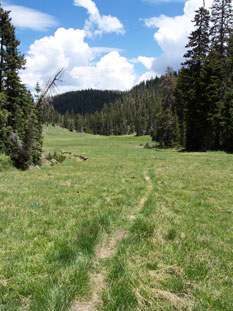
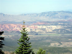
I was excited to be bagging my first peak…..and then we hit 9,000 feet, our first wall. The time between our breaks got shorter and shorter. Although, they didn't last long because as soon as the mosquitoes and flies smelled fresh meat about to die, they attacked. We hiked for over 3 hours before the sun even touched us. By that time, we were almost to the ridge where we could see 180 degrees to the West. It was a little hazy but we could easily see from the Red Mtn. above Ivins to Enterprise and a long way into Nevada. Once we reached the top of the ridge, everything South including St George came into view. Wow we were high!
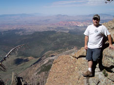
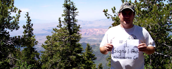
After taking in the vista, we headed for Signal Peak, which meant we had to cross a canyon before the final ascent. We took a guess and left the trail for the hike to the summit. We crested at 10,365 feet and bagged our first Peak. There was not much of a view from Signal peak because it is overgrown with pine, but it was nice to be looking at something besides a taller peak. After the photos and adding ourselves to the register, we started back down the dome to pick up the trail. 5 minutes after heading down, my left knee was hit with pain. I expected it. It has given me problems since running track my Senior year in High School. I hadn’t felt it hurting since October….and the deerhunt was usually the only time it would be given the opportunity to hurt. I don’t know why only on downhill but the steeper it was, the more my knee ached. I wasn’t really looking forward to the “easier” part of the hike. Soon my brother started complaining about his knee and my father fell victim to an old knee injury as well. We continued to hobble off the mountain, knowing we weren’t going to get any sympathy from one another.
We reached Further Water but figured we all had enough water in our packs to last and we didn’t want to risk getting sick for our campout next week and the attempt at Delano Peak. So we continued on, shrugging off the crystal clear and ice cold spring water. After heading downhill for a way, the trail suddenly started to head up. Why? Why up? It didn’t hurt the knee as much….but I was done with UP! After cursing the trail-blazers, saying we knew better than them ( even though only my father had been on this part of the mountain before….and that was 40 years ago) we had no choice but to trudge forward where the trail ultimately returned downhill.
With only about 1000 feet left to descend, the wind came up and it started to sprinkle. Soon the refreshing raindrops turned into larger drops and some hail. The thunder crashed a few times and we spent the rest of the way down walking in a pretty good rainstorm. We finally reached the bottom of the trail forcing us to find our "flat ground" legs again. All 3 of us limped down the road hoping a truck would pass to give at least one of us a ride back into Pine Valley Town to our car. A small pickup with Nevada plates finally passed going the right way and we shamelessly held out our thumbs. It took them about a block later to realize that the 3 wet, tired, shuffling hikers weren’t zombies and we quickly accepted their offer to ride in back. They stopped at the General store in Pine Valley and we walked the rest of the way to the Forsyth Trailhead. The car was a welcome site for our sore backs and pulsating feet.
We were done, and it was barely 5:00 pm. 14 miles total and the privilege of standing at the highest point in Washington County were ours. 28 more counties to go. The mountain was beautiful with streams gurgling down the canyons, wildflowers lapping up the last of the snow runoff and the strong unique smell of rain striking the dirt.
My next challenge to accomplish: trying to get out of bed in the morning….and to trick my sore muscles into letting me walk half-straight. I hurt.